Sunday, November 5, 2017. Hundreds were without power after 105 mile per hour winds came through the area. The cause? A microburst- a downdraft caused by a thunderstorm. One day later, over 23,000 people were still without power in the Northeast Ohio area. 9,107 people in Twinsburg alone had reported outages from the storm. At least 5 electrical poles were damaged as well as multiple homes in the area.
In the days following, The Twinsburg Public Library became a safe haven, providing respite for those suffering from the storm. Patrons filled chairs and even lined the hallway floors while charging their electronics in any available wall outlet they could find. Others took advantage of the library as a warming station. The library provided coffee and hot water for those who needed it.
Tree wreckage near the house on the corner of Laurel and Conrad. Luckily the large tree did not hit anything and caused no damage to the structure.
Image from Lisa Thomas Mercurio
The potential for a storm to spawn a tornado peaks during the heat of summer. Mother Nature decided to mix things up, however, when Ohio was rocked by an unusually late tornadic outbreak on November 10, 2002. News stations around the state had their hands full as nineteen tornadoes touched down across the region. One left a scar on the land and lives of area residents when damage and destruction from a swirling storm damaged dozens of homes and completely leveled others.
According to an issue of the Plain Dealer dated November 23, 2002, “Twinsburg, Macedonia, Solon and Glenwillow filed a joint application to the Federal Emergency Management Agency for emergency funds to help pay for recent tornado damage, said Macedonia Mayor Barbara Kornuc. Public officials have asked FEMA to consider their communities one disaster area. The communities will have to pay a total of more than $500,000 to clean up damage.”
According to the National Oceanic and Atmospheric Administration:
A small F0/F1 tornado touched down in Macedonia near the intersection of Valley View Drive (SR 631) and Aurora Road and moved northeast. The tornado gradually strengthened and reached F2 intensity as it crossed State Route 14 and moved into Twinsburg. Extensive damage was done in Macedonia and Twinsburg. In Macedonia, 60 homes were damaged including two that were destroyed and 15 others were damaged enough to be declared uninhabitable. The most severe damage in the county occurred in the Glenwood Preserve neighborhood on the north side of Twinsburg. Extensive damage was done on Andover Drive and Deeplake Circle where several homes were leveled and a total of 45 homes damaged. Damage estimates in Twinsburg alone were well over $5 million. The damage path was continuous and about 100 yards in width. Dozens of cars were damaged or destroyed and hundreds of trees and power poles downed in Summit County.
During the Thanksgiving Blizzard of 1950, forty-mile-per-hour winds socked the region, and a blanket of snow more than one foot deep covered the land. Areas farther east fared worse, with some Ohioans recording more than two feet. The culprit was an extratropical cyclone that paralyzed the area unlike any storm during the prior three decades. Temperatures hung near zero, freezing water lines and killing car batteries. Nationally, 353 souls perished due to the storm. Many sources compare the storm’s ferocity to that of the 1913 storm that crippled the region for five days. Estimates place fatalities for that storm at over 250. In Cleveland, the Ohio National Guard provided support in light of the countless police officers unable to make it in to work. Many of those enjoying family and festivities over the Thanksgiving holiday were forced to extend their stay.
Image taken from Cleveland Plain Dealer. See full article here: http://media.cleveland.com/remembers/other/snowstorm.pdf
No mere snow squall or winter gale, this storm was known to those who witnessed its icy wrath as “The Great Blizzard.” The front slammed the region, dropping the mercury to dangerous lows and pumping out snow to incredible heights. It began on January 23, as it moved west toward the Ohio Valley. On January 25, forecasts for the state began to paint a more severe picture of things to come and by nine p.m. a blizzard warning was issued for the entire state of Ohio. Scott and Sue Kollman of Kollman’s grocery store conveyed the frantic state of locals as the storm approached, saying, “Everyone was scared . . . there was a run on the store.” The next day, President Jimmy Carter declared a state of emergency for Ohio. This would mark the peak of the blizzard’s strength, with wind speeds topping eighty miles per hour in Cleveland. It would be another two days before the storm broke and an assessment of the damage could take place.
Of the storm’s aftermath, local Andrew Miller nostalgically remembered it as only a small boy could have: “I remember the snow being up to my knees, which at the time probably would’ve been two feet . . . No plows had been through yet, nobody had shoveled after, it was still storming and you just couldn’t tell the difference between the road and someone’s front yard. It was just an even plain.” His mother Sandy told how theirs was the only home in their neighborhood with a wood-burning fireplace, presenting a warm and inviting refuge for nearby neighbors without heat . . . providing they were capable of braving the storm. And for some, that bravery came from the insatiable need to eat, drink, and be inebriated. “Nobody could go to work, but Babka’s was packed,” according to the Kollmans. The following is taken from a bulletin by the National Weather Service:
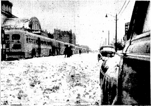
Still images and film footage were combined, documenting many of the familiar sights around Twinsburg as they appeared during the now infamous blizzard. Public Square, shops and storefronts, Corbett’s Farm, and rural byways are shown coated in snow, reflecting the true ferocity of the storm in its immediate aftermath. Film footage of the 1978 blizzard was captured by Twinsburg resident James Kizak.
The following content are the actual press releases from the National Weather Service illustrating the evolution of the storm from January 24-26:
SPECIAL WEATHER STATEMENT NATIONAL WEATHER SERVICE AKRON OHIO 100 PM EST FEB 1 1978 …THE BLIZZARD OF 78… TUESDAY JAN 24…TWO SEEMINGLY UNRELATED LOW PRESSURE AREAS SEPARATED BY VAST DISTANCES…ONE IN THE WESTERN GULF OF MEXICO THE OTHER IN NORTHERN NORTH DAKOTA…BEGAN TO BECOME ORGANIZED. THE NORTH DAKOTA LOW WAS EXPECTED TO PASS NORTH OF OHIO POSING NO GREAT WEATHER THREAT TO THE STATE OTHER THAN TO BRING IN COLDER AIR. THE GULF LOW WAS FORECASTED TO MOVE GRADUALLY NORTHEAST UP THE MISSISSIPPI VALLEY TO THE OHIO VALLEY AND THEN NORTHEAST OF OHIO. RAIN WAS EXPECTED TO SPREAD INTO THE STATE FROM THIS LOW…CHANGING TO SNOW AS THE COLDER AIR MOVED IN BEHIND. WEDNESDAY JAN 25…ALL THINGS SEEMED TO BE OCCURRING AS FORECASTED AS THE GULF LOW MOVED INTO NORTHERN LOUISIANA DURING THE MORNING. THEN THE FIRST SIGNS OF SOMETHING MORE OMINOUS BEGAN TO APPEAR. THE NORTH DAKOTA LOW STARTED TRACKING MORE SOUTHEAST AND PRESSURES NORTH OF THE GULF LOW BEGAN TO FALL RAPIDLY. IT BECAME APPARENT THAT THE TWO LOWS WERE ON A VIRTUAL COLLISION COURSE AND THAT COLLISION WOULD TAKE PLACE IN OR VERY NEAR THE STATE OF OHIO. PRESSURES CONTINUED TO FALL RAPIDLY AHEAD OF THE GULF LOW AS WARM MOIST AIR WAS BROUGHT NORTH. BY AFTERNOON HEAVY SNOW WARNINGS WERE ISSUED FOR NORTHWESTERN COUNTIES OF OHIO AND A WINTER STORM WARNING FOR THE REMAINDER OF THE STATE. BY EARLY EVENING THE PRESSURES HAD DROPPED TO RECORD LOWS THROUGHOUT THE BUCKEYE STATE AND THE COLD LOW FROM THE NORTH WAS TRACKING DIRECTLY TOWARD OHIO. IT NOW BECAME VERY OBVIOUS THAT A VERY DANGEROUS WEATHER SITUATION FACED OHIOANS AND BLIZZARD WARNINGS WERE ISSUED FOR THE ENTIRE STATE AT 9 PM. TEMPERATURES ROSE INTO THE 40S AND RAIN CONTINUED AS THE DAY NEARED ITS END. THE WIND INCREASED GREATLY TOWARD MIDNIGHT AND THE PRESSURE CONTINUED ITS DOWNWARD SLIDE. THURSDAY JAN 26…BY EARLY THURSDAY HERE AT THE AKRON CANTON WEATHER SERVICE OFFICE THE WIND HAD RISEN TO SUSTAINED SPEEDS BETWEEN 25 AND 30 MPH GUSTING TO OVER 40 MPH. THE PRESSURE WAS STILL DROPPING AND IT WAS EVIDENT THAT A STORM OF UNPRECEDENTED MAGNITUDE WAS IMMINENT. AT 347 AM THE BAROMETER REGISTERED 28.33 INCHES…A FULL HALF OF AN INCH LOWER THAN THE PREVIOUS RECORD LOW OF 28.83 INCHES SET ON FEB 25 1961. WIND WAS NOW BLOWING AT 30 TO 40 MPH AND GUSTING TO OVER 50 MPH. BY 430 AM THE COLD AIR MOVED INTO THE LOCAL AREA. TEMPERATURES DROPPED RAPIDLY AND THE RAIN CHANGED TO SNOW. THE WIND WAS NOW GUSTING TO OVER 60 MPH AND AT 512 AM A PEAK GUST OF 76 MPH WAS RECORDED. BETWEEN 5 AND 6 AM THE TEMPERATURE FELL 21 DEGREES FROM 34 TO 13 AND EVERYTHING THAT WAS WET FROM THE RAIN BECAME ICE. THE TEMPERATURE LEVELED OFF AROUND THE 10 DEGREE MARK BUT THE WIND REMAINED HIGH… SUSTAINED AT 25 TO 35 MPH AND GUSTING TO 40 AND 50 MPH DURING THE ENTIRE DAY. REPORTS OF DAMAGE BEGAN TO POUR IN OF POWER LINES DOWN… TELEVISION ANTENNAS BROKEN OFF…TREE LIMBS AND WHOLE TREES DOWN… AND BROKEN WINDOWS. ROADS HAD BECOME VAST SKATING RINKS AND DRIVING WAS ALL BUT IMPOSSIBLE. THE SNOW WAS BLOWING AND DRIFTING REDUCING THE VISIBILITY TO NEAR ZERO. WIND CHILL FACTORS DURING THE DAY FELL FAR BELOW THE MINUS 60 DEGREE MARK MAKING VENTURING OUTSIDE EXTREMELY HAZARDOUS. BLIZZARD WARNINGS WERE CONTINUED THROUGHOUT THE DAY AS OHIO REELED UNDER WINTERS WORST STORM IN MANY YEARS. WINDS REMAINED HIGH…SNOW BLEW AND DRIFTED…AND ALL TRAVEL AND OUTDOOR ACTIVITY CAME TO A VIRTUAL HALT. THIS SITUATION CONTINUED INTO FRIDAY WITH THE BLIZZARD WARNINGS BEING REPLACED BY TRAVELERS ADVISORIES AT 440 AM FRIDAY MORNING. THESE ADVISORIES REMAINED IN EFFECT THROUGHOUT FRIDAY AS THE WINDS DIMINISHED BUT WERE STILL STRONG ENOUGH TO CAUSE CONSIDERABLE BLOWING AND DRIFTING…AND RESTRICTING VISIBILITY ON THOSE ROADS THAT WERE OPEN. WIND CHILL FACTORS OF MINUS 40 TO 60 DEGREES CONTINUED AS WINDS BLEW FROM 25 TO 40 MPH AND TEMPERATURES HOVERED IN THE TEENS. FOR SHEER MAGNITUDE…THIS MUST RANK AS THE WORST STORM TO HIT THE GREAT LAKES REGION IN MANY YEARS. ON THE WEATHER SIDE…RECORD LOW PRESSURE READINGS…HIGH WINDS…DRAMATIC TEMPERATURE DROPS AND CONSIDERABLE BLOWING AND DRIFTING SNOW WERE ALL BUT UNPRECEDENTED. ON THE HUMAN SIDE…THE SUFFERING…DISCOMFORT AND DANGER CAUSED BY DISRUPTED POWER…WIND DAMAGE…STRANDED AUTOMOBILES AND OTHER STORM RELATED EVENTS WERE PROBABLY MORE WIDESPREAD THAN IN ANY OTHER STORM IN MOST PEOPLES MEMORIES. MANY WEATHER RECORDS WERE BROKEN BUT THAT IS WHAT RECORDS ARE FOR AND THOSE ARE JUST COLD STATISTICS. UNFORTUNATELY THERE ARE NO RECORDS OR COLD STATISTICS TO MEASURE THE HUMAN FACTOR IN A STORM OF THIS VAST SCALE.
It’s easy to imagine the smell of warm, freshly baked bread wafting from the ovens of a Brownberry factory. This pleasant scenario, however, was not the one that unfolded during the morning hours of October 13, 1980. Beginning during the predawn hours, flames rapidly engulfed the confines of the brick Brownberry warehouse, causing $300,000–$500,000 in damage. While those figures were provided by fire officials, corporate officials put the pyre’s price tag at nearly $4 million. No word on whether that figure included the loss of ten thousand cases of croutons and stuffing.
It can be surmised that the cardboard and crouton kindling only served to exacerbate things. The one-story building and the fire that it fueled would require more than five hours of assistance by sixty-seven fire responders from Twinsburg, as well as Hudson, Macedonia, and Northfield Center Township. Per the Plain Dealer, “No one was hurt . . . but two Twinsburg fireman were covered with lard when a lard tank exploded.” Betty Tomko, the first female firefighter, worked a hose line at the fire. Luckily, no one was injured. {Courtesy of the Twinsburg Bulletin} 66. Three Communities, One Heritage stated, “When they turned the water on, it just wiped us all over the blacktop, because lard had melted inside the facility that they used for the bread.” It made those using the hose slip and slide uncontrollably. The fight could have taken much longer had the fire spread to the offices, but a functioning sprinkler system and interior brick wall held the flames at bay.
After a strenuous day battling the Brownberry blaze, firefighters would respond to an eerily similar call when the second of two warehouses operated by the bread company caught fire just a street away. Although smaller and less destructive, the fire at the warehouse suggested something more sinister was going on. A year and a half earlier, in February 1979, another fire caused more than $60,000 in damage to the Brownberry store in Bedford Heights. The Plain Dealer reported the fire’s origins as “suspicious” in nature. When taken as a whole—three fires in two years—the coincidences become too strong to ignore, suggesting something nefarious was at work. In the end, no one was ever arrested in connection with these events.
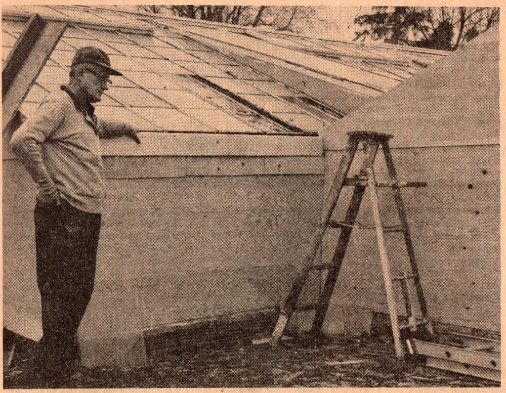
A bombing, a greenhouse, and political dissatisfaction: together, they might set the scene for a run-of-the-mill crime novel. This, however, was no dime-store rag, but a very real list of circumstances for the events that unfolded on February 12, 1969. Carl Herrick’s Greenhouse, once located at 8935 Ravenna Road (currently Kollman’s Greenhouse), was rocked when a strategically placed stick of dynamite tore through the glass and greenery.
Carl Herrick, greenhouse owner and operator, stands feet away from where a stick of dynamite ripped through
“At approximately midnight last Wednesday, a bomb was placed at the base of the front wall of Carl Herrick’s Greenhouse. Mr. Herrick didn’t hear the dynamite explode. At 2:00 a.m. he was awakened by an alarm from the greenhouse indicating that the temperature was dangerously low. The glass windows covering the front wall of the greenhouse had all been blown out, and the freezing winds had killed all the vegetation within 15 feet of the wall. Friends worked with Herrick through the night to cover the wall so that no greater loss would be suffered. Most speculated that Herrick, a Twinsburg Township Trustee, was the target of this destructive action because of his views on annexation. Mr. Herrick doesn’t know. He feels that the only enemies he has are political, and he doesn’t feel that his political enemies would stoop so low.”
Reports from the Twinsburg Bulletin indicated that Carl Herrick’s views on further secession and annexation, pertaining to Twinsburg Heights and the Township, could have sparked the greenhouse bombing. No suspects were apprehended in connection with the bombing, and no additional violence against plants was reported.
Andrew Miller discusses how his neighborhood lost power during the Blizzard of 1978 and several families took shelter with his family, who happened to own a wood burning stove.
Two lives collided along the byways south of Twinsburg on an early morning in 1913. Two men unaware of one another, raced toward an arbitrary spot where their lives would end at 90mph. As they headed toward one another, William Thompson of Akron, and Frank Novak of Cleveland, collided. Blame was placed on Frank Novak and his faulty motorcycle. Having left that morning from Cleveland intending to participate in an endurance run to Youngstown, the young Mr. Novak soon began experiencing mechanical problems. A short break outside Twinsburg gave him time to look over the motorcycle and make a few quick adjustments.
Assuming he had corrected the issue, he jumped back on his motorcycle and took off, intent on catching up to his fellow riders. At the moment Mr. Novak lost control, his bike veered into Thompson; the force of the collision sent each man flying from his machine. According to news reports, “Thompson was found by Mrs. Hoff unconscious and bleeding from a dozen wounds. Novak had retained consciousness, but was unable to speak.”
Residents in the vicinity of the collision reached Dr. R.B. Chamberlain by phone. He wasted little time, making it to the two men as quickly as possible. Thompson died quickly. Novak held on a bit longer, dying en route to the hospital.